Upper East Canyon Hikes
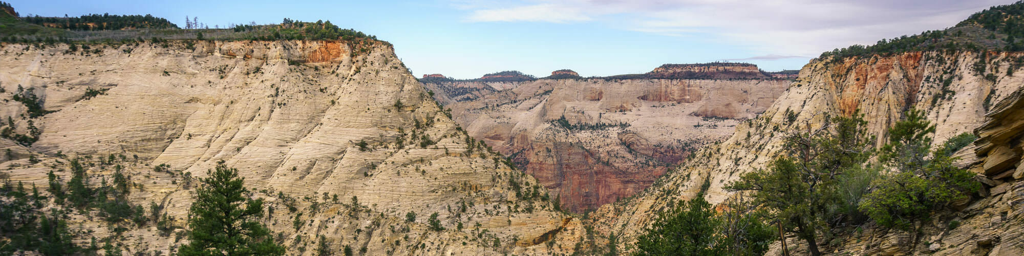
The upper east section of Zion National Park offers beautiful scenic drives that won’t soon be forgotten. Route 9 is an amazing route that carves a tremendous snaking path leading to the gorgeous slickrock drainages and formations in the Upper East Canyon. The route is connected to the main canyon through the beautiful Zion-Mount Carmel Tunnel. This section doesn’t offer many official trails, but you can enjoy several sandstone formations, minor peaks and drainages that can be explored and offer outstanding photograph backdrops. The slickrock formations offer a relaxing, pleasant feeling to the area. This section is home to the Checkerboard Mesa, a famous Zion formation. You can also spot several bighorn sheep along the road.
Canyon overlook
This trail is rated as a short, easy, family friendly hike. This classic trail is considered as an official trail in the Upper East Canyon. Although this is a shorter trail, you are sure to enjoy it as well as the grand viewpoint through the main canyon. As you travel farther, you can enjoy the beautiful views of the Pine creek slots, as well as small breaks in cool shades at the alcove. Enjoy the lush greenery on the walls making a unique sight while hiking. This is a must-do hike for beginning hikers who are visiting the Zion for the first time.
East Rim Trail
Many hikers are familiar with the lower section of the East Rim Trail that takes you to Observation Point and Hidden Canyon trail, but very few hikers know about this longer, 11 mile, East Rim trail. The East Rim may not offer as much excitement as the West rim trail, but it sure to offer you gorgeous scenery from the entrance to Echo Canyon and further down to Weeping Rock in the main Zion Canyon.
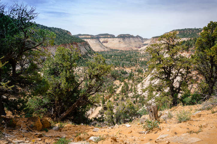
A view of the East Canyon of Zion National Park
Clear Creek
Clear Creek trail is rated as a fairly easy hike. Although it is not an official trail, it offers adventure to hikers with several areas to explore. This particular section is a dry streambed which follows Route-9 and spreads through the entire East Canyon. This is a gorgeous canyon, with many sections that are looped together. You may get confused at first, but you will soon figure it out. This kind of adventure is recommended to those wanting to explore.
Gifford Canyon
This strenuous hike is a north-south wash is located at the east part of Zion Mount Carmel Tunnel in the UPC (Upper East Canyon), south of Route-9. You can also reach the Gifford Canyon from the Canyon Overlook Trail parking lot just across the trail. It is mostly an open wash that contains a few sandy areas scattered with small sections of uncovered slickrock in the streambed. However, this trail is not as scenic as other sections in Zion, but will still make for an interesting day or a half-day hike for those looking forward to adventure and exploration opportunities.
Bridge Mountain Arch
This tough hike is a technical backpacking route and is considered an isolated landmark. You can view the Bridge Mountain Arch from the Zion Museum. Apart from being a strenuous and long hike, this isolated route begins in the Upper East Canyon and takes you through Gifford Canyon as it leads you to several up and down washes until you finally reach the Bridge Mountain Arch. It can be a very long and tiring route and hikers may face several challenges along the way such as short technical climbs, but the views are rewarding.
Pine Creek
This strenuous, technical canyoneering trail is one of the most famous canyoneering routes in Zion National Park. The section is known for it’s outstanding, subterranean slot canyons. The trailhead starts at the parking lot of Canyon Overlook and the trial ends at Route 9, in the main canyon. This beautiful Pine Creek slot is one of few other slots that feature an easy access. Though some might consider it as an easy, yet technical canyoneering trail, it is can still be tiring. The trail has several down climbs, rappels and cold water swims. The route also features a gorgeous Cathedral section which features an arched doorway, leading you to the last and final 105 foot free rappel.
Upper Pine Creek
This off-trail hike, has a creek with a large north-south drainage that traverses under Route-9, approximately 0.4 miles east of the entrance of the Zion Mountain Carmel Tunnel. This creek flows north from the route a mile and half and the trail can be finished in half a day. Remember, Upper Pine Creek is not same as (Middle) Pine Creek. This trail is little strenuous and is preferable for experienced hikers.
The East Temple Loop
This strenuous, rock-scrambling off-trail route, is considered an unofficial trail and begins at the end of the Canyon Overlook trail. Once you’ve reached the viewpoint, take the northeast route to reach the saddle which is located under the East Temple trail. Once there enjoy the view of the gorgeous slickrock formations and their surroundings of the Upper East Canyon. The trail then goes down to the side canyon into the UPC (Upper Pine Creek), which then completes the East Temple loop. Hikers must have good navigation skills and ability to figure out rock-scrambling. The trial is suggested for experienced hikers.
Shelf Canyon
This tougher off-trail hike is different from others due to its several little cracks and canyons located along the way. Many of these canyons have no official names. Self Canyon is an interesting little canyon, that is worth exploring. The upper part of the Canyon slots leads into a dark alcove with shelf formation ledges forming along the west wall, leading to the end of this hike. This off-trail hike is suggested for experienced hikers.
Progeny Peak & Two–Pines Arch
This trail is classified as a moderately strenuous, rocky trail. Peak 6275, unofficially known as Progeny Peak, is an unnoticed mountain structure in the East Canyon, located to the east of East Temple Trail and UPC (Upper Pine Canyon). You can complete this hike in a few hours as you enjoy the outstanding view offered from all directions. The trail is a steep, off-trail route. Be careful as there may be a chance of rock slides along the trail. Good navigation skills are a must in attempting to take on this trial. Two-Pine Arch is a tiny arch formation that is visible along the trail.
Many Pools
This trail is rated as a fairly strenuous trail. To reach the east tunnel in the Upper East Canyon takes less than half a mile and it has several unofficial nicknames. East Root Canal is popularly known as “Many Pools” by locals, because of its remarkable pothole formations. This lovely open wash is enjoyed by visitors who can enjoy the gorgeous sandstone scenery which is especially remarkable during the spring.
Keyhole Canyon
This short technical canyoneering trail, Keyhole Canyon, also known as starfish canyon, is an isolated trail that hardly shows up on top of the map. Considered as a beautiful little subterranean slot canyon, this trail is a short and exciting trail in the Upper East Canyon. It’s a short technical-canyoneering venture that can be completed within 2 hours. It contains 2 to 3 rappels, several down climbing obstructions and a few cold water swims and wades. You must have full technical gear and wetsuits for this hike. This particular canyoneering route is suitable for beginners, as they can complete the trail just in 2 hours, but it can require additional experience.
Jughandle Arch
Rated as a tougher route, Jughandle Arch is an impressive arch formation in the East Canyon, located high above the Keyhole Canyon. People with an eagle eye can spot the arch from down on the road through the tunnel. The section offers many rocky hiking routes to make your trip more interesting. You can also enjoy saddle hiking just under the arch, with plateau hiking available above the arch. There is an optional return route available through the west Canyon which is also known as the “Center of the Universe”.
South Ariel Peak
This trail is accessible towards the peaks of the Upper East Canyon, which is located on route-9 towards the famous Keyhole Canyon trail. It is located near the South Ariel Peaks and offers spectacular views from the peak. The route is short and it’s easy to cover the lower section, but note that there is a scary steep Class 4 pitch at the top with exposure to the razorback peak making this route tiring. When adventuring this trail be prepared for rock sliding obstacles.
Jolley Gulch
This short day hike is located in the Upper East Canyon located next to the East Rim Trail. Visitors can see the Jolley Gulch from the top of the East Rim Trail. This hike makes for a pleasant stroll that everybody can enjoy, where all age groups can find something interesting along the route.
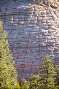
View of Checkerboard Mesa Canyon's unique cross-hatching pattern
Checkerboard Mesa Canyon
This strenuous hike features a unique cross-hatching pattern on the white cliffs cone-shaped formation makes it unique and one of the most identifiable and picturesque landmarks in ZNP. Visitors can enjoy the beautiful formations at the Checkerboard Mesa viewing area. The west side is informally known as Checkerboard Mesa Canyon and can be enjoyed by all age groups. This particular route is also the entrance for longer hikes on the Parunuweap part of the White Cliffs.
Separation Canyon – Nippletop, Separation Peak and Lonely peak
This trail is rated as a strenuous day hike. The UEC has surplus of drainages that allow you to explore the section while offering interesting adventures at “Separation Canyon”. The hike towards the wash takes only half a day, as does the hike to Many Pools which contains several options to explore. Separation Peak offers great views towards south and north. Nippletop is sure to add to your hiking experiences. The further south you hike you’ll reach the beautiful “Lonely Peak”.
Cockeye Falls to Lost Peak and Crawford Wash
This day hike is located on the South Route-9, 0.4 miles towards the east, shorter tunnel, known to locals as Cockeye Falls. It is one of the most prominent landmarks in the East Canyon. The Cockeye Falls hike gives a unique experience to hikers with its interesting route that allows hikers to enter the Crawford Wash, which is considered as a large south facing washes of the section, and Parunuweap side of the White Cliffs .
The Barracks and Upper Parunuweap Canyon
This hike is rated as a moderately strenuous, backpacking route. The BLM territory of the NPs boundary is a gorgeous and isolated stretch of canyon known as The Virgin River’s East Fork, or The Barracks. This backpacking route begins at Route-89 and leads to Mt. Carmel Junction. From the junction the route leads to the East Fork, making the entire route a 20 mile trip. The Barracks are considered as the golden section where the tall walls are narrow, similar to the popular Zion Narrows.
Note: Lower Parunuweap Canyon in Zion National Park is an exclusive NRA (Natural Research Area), to complete the route getaway by Checkerboard Mesa.
Misery Canyon
This technical canyoneering trail borders the Eastern border of Zion National Park which is considered as more of a technical canyon. The canyon is located outside of the Zion Park, but has a hike beginning at the Checkerboard Mesa Canyon. It is a difficult canyon with a long strenuous hike that contains several rappels, several down climbs, and a few inactive pools to go through. The trial ends at the stunning Barracks section at the East Fork of the Parunuweap Canyon of the Virgin River.
Meadow Creek & Mineral Gulch
If you’ve ever driven between the entrance of Mt. Carmel Junction and Route-9 you might have observed the exciting Mineral Gulch Canyon and Meadow Creek that lead south into the mysterious and deep Parunuweap Canyon. The scenic view in Mineral Gulch and Meadow Creek may not be as stunning as other canyons, but you are sure to enjoy the interesting isolated hiking experience offered on this route.
Poverty Trail
The Poverty trail was once an old cattle road, but is now a dirt road that is connected to the BLM road from Route-9 south. Large vehicles can drive up to a certain point, but cannot go beyond. The last 2 miles of the route are very rugged and contain sand. It is considered as one of the quickest routes to the Barracks.
Petroglyph Canyon
This route is rated as a fairly easy hike. A Petroglyph is a kind of secret area, after thorough research and references made by the experts on Petroglyph Canyon amongst other research, proved the existence of Petroglyph Canyon. Some important things to remember when visiting is to not lean or touch any rocks as they are considered as cultural treasures. If you have any doubts, don’t hesitate to ask a ranger at Visitor Center.
These are some of the popular, strenuous and easy trails in Upper East Canyon that can be enjoyed by all. Although the list contains only a few official trials, each trials provides excitement and spectacular views along the way. Visit these sections of the park to make memories that last.